Distribution line inspection software helps utilities turn thousands of pole and span photos into organized, prioritized repair work. The best way to use it is feeder by feeder: map the assets, fly the circuit, let the software sort and check the images, then tag and route what needs fixing.
Utileyes builds drone inspection software for utilities, and its founders personally flew more than 10,000 utility inspections before building it. This post walks through how distribution teams can structure feeder work in software so findings reach crews fast, and what to look for along the way.
Quick Summary
- Distribution line inspection software organizes drone and field imagery by pole, span, and circuit so reviewers don't sort photos by hand.
- Working one feeder at a time keeps flights, reviews, and repairs tied to the way crews already think about the system.
- Built-in QA catches misplaced or mismatched images at upload, before a bad photo becomes a missed defect.
- Severity tagging by outage risk, fire hazard, or safety lets supervisors dispatch the worst problems first.
- Exporting findings to GIS and work order systems closes the loop from photo to repair.
What is distribution line inspection software?
Distribution line inspection software is a platform that plans, organizes, reviews, and reports inspections of the poles, conductors, and equipment that carry power from substations to customers. It matches each photo to an asset, gives reviewers a consistent inspection form, and turns findings into reports or work orders a crew can act on.
Distribution systems are dense. A single feeder can run through neighborhoods, farmland, and rights of way, with poles carrying crossarms, insulators, cutouts, transformers, and service drops. Generic drone or photo apps leave teams to rename files and build spreadsheets. Purpose-built software handles that structure for you.
Why should utilities inspect distribution lines feeder by feeder?
Inspecting feeder by feeder ties every flight, photo, and finding to a circuit that operations already tracks. Supervisors can see which feeders are complete, which have open findings, and where crews need to go next. It also keeps review batches a manageable size so nothing sits in a queue for weeks.
Reliability is the reason the work matters. The U.S. Energy Information Administration reported that electricity customers experienced an average of 11 hours of interruptions in 2024, with major events accounting for nearly nine of those hours. Finding worn hardware and hot connections before a storm is one of the few parts of that number a utility can influence ahead of time.
How a feeder-based workflow runs
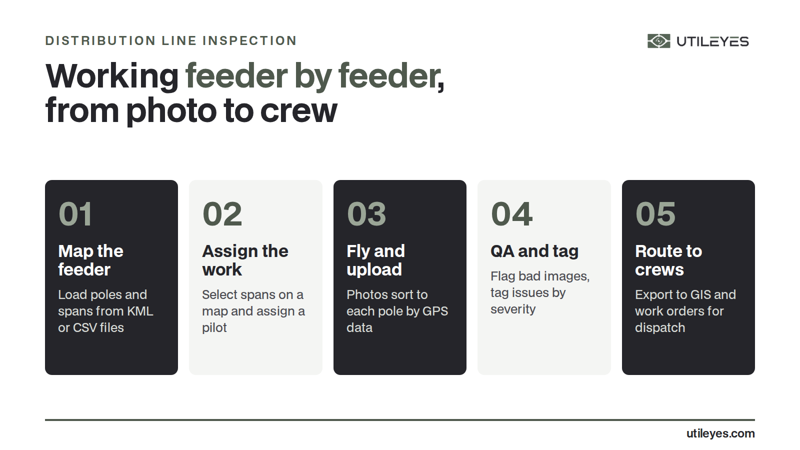
- Map the feeder. Load poles and spans from a KML or CSV file, or generate asset points during flight.
- Assign the work. Draw a selection around the poles or spans on a map and assign them to a pilot.
- Fly and upload. Pilots capture RGB and, where needed, thermal images, then drag and drop the files in.
- Check and review. The software sorts photos by asset using GPS data and flags images that don't match the mapped asset.
- Tag and route. Reviewers tag each issue by severity, then export findings to GIS or work order systems for dispatch.
What should distribution line inspection software do?
At minimum, it should connect each image to the right pole, give reviewers a form that matches your inspection standards, rank findings by risk, and hand results to the systems your crews already use. If any of those steps still depends on spreadsheets or manual file renaming, the software is only solving part of the problem.
| Capability | Why it matters on distribution circuits | Question to ask a vendor |
|---|---|---|
| Asset mapping from KML or CSV | Starts every feeder from your real pole and span records | Can we load our existing asset files as they are? |
| Automatic photo sorting by GPS | Removes manual photo sorting after every flight day | How are photos matched to poles, and what happens when GPS is off? |
| QA at upload | Catches wrong or missing shots while the pilot is still nearby | Does the system flag mismatched images before review starts? |
| Custom inspection forms | Keeps reviews consistent with your own standards | Can we build forms for crossarms, insulators, and transformers separately? |
| Severity tagging | Separates urgent repairs from routine maintenance | Can we set severity levels to match our outage, fire, and safety priorities? |
| GIS and work order export | Moves findings straight into existing maintenance pipelines | Does it export in formats our GIS team already uses? |
What defects do distribution inspections look for?
Distribution inspections focus on the hardware most likely to fail or cause a fault: damaged or leaning poles, cracked or rotting crossarms, chipped or flashed insulators, loose or corroded connections, damaged cutouts and arresters, leaking transformers, and vegetation contact. Thermal imaging adds a way to spot overheating connections that look normal in a regular photo.
Drones help because many of these problems sit on top of the pole, where a ground patrol has a poor view. A top-down or side angle photo can show a split crossarm or a cracked insulator that is hard to see from the road. The software's job is to make sure every one of those photos is tied to the right pole and reviewed with the same checklist.
RGB and thermal together
RGB photos show physical damage such as cracks, burns, rust, and missing hardware. Thermal images show temperature differences, which can point to loose connectors or overloaded components before visible damage appears. Reviewing both side by side, on the same asset record, gives a more complete picture than either alone.
How do you get findings from the photo to the crew faster?
The fastest path is to remove the handoffs. When photos are sorted automatically, checked at upload, tagged by severity in one place, and exported straight to work orders, there is no waiting on a vendor report or a spreadsheet. With Utileyes, teams can go from a photo captured to a crew dispatched in as little as 15 minutes.
Speed matters most for high severity findings. A cracked insulator near a busy road or a hot connection on a heavily loaded feeder should not wait for the next monthly report. Clear severity levels let a supervisor sort the list and send the right crew first.
Should distribution inspections be done in-house or outsourced?
Many utilities now run distribution inspections with their own drone teams and use software to handle the data work that vendors used to do. Utileyes reports inspection costs about 50% lower than outsourcing to vendors, and the data stays with the utility instead of in a vendor's queue.
An in-house approach works best when the software is simple enough for linemen and pilots to learn quickly. Utileyes was built with utility linemen and drone pilots, and its leadership team brings more than 50 years of combined utility operations experience. That field background shows up in small details, like assigning spans on a map instead of in a spreadsheet.
For a closer look at each step, see how Utileyes works or the Utileyes FAQ. If you are comparing operating models, this post on outsourced vs in-house drone programs covers the tradeoffs.
Frequently Asked Questions
What is the difference between distribution and transmission line inspection?
Distribution inspections cover the lower voltage lines and poles that deliver power to homes and businesses. Transmission inspections cover high voltage lines on larger structures that move power over long distances. Distribution systems usually have far more poles and more equipment types per mile.
Can drones inspect distribution poles without an outage?
Drone inspections are typically done from a safe distance and do not require touching the line. Pilots follow their utility's safety rules and FAA requirements for each flight. Always confirm procedures with your own safety and operations teams.
What images should be captured on each distribution pole?
Most utilities capture the pole top, crossarms, insulators, and attached equipment from several angles, plus the pole base. A consistent shot list for each pole type makes reviews faster. Thermal images are added where hot connections are a concern.
How does software match drone photos to the right pole?
Utileyes uses the GPS location in each photo's metadata to match it to the nearest mapped asset and organize photos by asset ID. Its built-in QA flags images that look mismatched or misplaced so they can be reassigned before review.
Does distribution line inspection software replace our GIS or work order system?
It shouldn't. Good inspection software feeds the systems you already have. Utileyes exports CSV files compatible with ArcGIS and ESRI and integrates with GIS and work order systems, so findings flow into your existing maintenance process.
Next Steps
Distribution line inspection software pays off when it matches how crews already work: feeder by feeder, pole by pole, with the worst problems handled first. If your team is still sorting photos by hand or waiting on vendor reports, it is worth seeing the workflow in action. Schedule a demo to see how Utileyes takes a feeder from photo to dispatch.